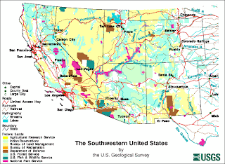
Digital Line Graphs (DLG) are used by the U.S. Geological Survey (USGS) to show a variety of information using the vector data format and georectification. Vector data format is similar to a point and line map. These Graphs can show topography, hydrography, boundaries, roads, and utility lines.
The map shown is a Digital Line Graph (DLG) Map displaying Federal Land types. The map is similar to a thematic map but it is created using a vector data format and georectification by the USGS therefore it is extremely accurate.
http://geochange.er.usgs.gov/sw/resources/sw_basemap/

No comments:
Post a Comment